Ficheiro:City Lights 2012 - Flat map crop.jpg
Saltar para a navegação
Saltar para a pesquisa

Dimensões desta antevisão: 800 × 428 píxeis. Outras resoluções: 320 × 171 píxeis | 640 × 342 píxeis | 1 024 × 548 píxeis | 1 280 × 685 píxeis | 2 560 × 1 369 píxeis | 11 358 × 6 075 píxeis.
Ficheiro original (11 358 × 6 075 píxeis, tamanho: 5,11 MB, tipo MIME: image/jpeg)
Descrição do ficheiro
Descrição do ficheiro
| Descrição |
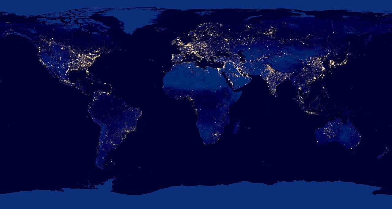
English: Composite view of Earth at night from the Suomi NPP satellite in polar orbit 512 miles above the surface, from April 18, over nine days and for 13 days ending October 23, 2012. |
| Data | |
| Origem | http://www.nasa.gov/mission_pages/NPP/news/earth-at-night.html |
| Autor | NASA Earth Observatory |
| Outras versões | File:City Lights 2012 - Flat map.jpg |
Licenciamento
| Este ficheiro está no domínio público nos Estados Unidos porque foi criado exclusivamente pela NASA. As orientações sobre o direito de autor da NASA são que «as obras da NASA não têm os direitos de autor protegidos salvo indicação em contrário». Veja Template:PD-USGov, as orientações sobre o direito de autor da NASA ou as normas de uso de imagens do Laboratório de Propulsão a Jato (Jet Propulsion Lab, JPL). | ||
 |
Avisos:
|
Histórico do ficheiro
Clique uma data e hora para ver o ficheiro tal como ele se encontrava nessa altura.
| Data e hora | Miniatura | Dimensões | Utilizador | Comentário | |
|---|---|---|---|---|---|
| atual | 00h51min de 21 de março de 2019 | | 11 358 × 6 075 (5,11 MB) | wikimediacommons>Materialscientist | {{LargeImage}} =={{int:filedesc}}== {{Information |description={{en|1=Composite view of Earth at night from the Suomi NPP satellite in polar orbit 512 miles above the surface, from April 18, over nine days and for 13 days ending October 23, 2012.}} |date=2012-12-06 |source=http://www.nasa.gov/mission_pages/NPP/news/earth-at-night.html |author=NASA Earth Observatory |permission= |other_versions=File:City Lights 2012 - Flat map.jpg |other_fields= }} =={{int:license-header}}== {{PD-USGov-... |
Utilização local do ficheiro
A seguinte página usa este ficheiro: